Sunday 11 July 2021

An expanded Committee for the CPPA


The CPPA Annual General Meeting was a resounding success with three new brains - Selma Barry, Nico Marcar and Prue Bedford - joining the governance board of the Association. Along with the returning stalwarts, Harvey Mitchell, Ian Dennison, Tony Dynon and Suzanne Pritchard, this collection of committed community enthusiasts will endeavour to determine a positive direction for the CPPA, ensure best use of its assets and implement its objectives.

The CPPA committee meets every odd month, 3:30-5:30pm at the hall. Interested members are always welcome to join us.

An annual report was compiled for the AGM and circulated to members prior to the AGM. The complete report is available online for your perusal.

President’s Thoughts-Suzanne Pritchard


The 2020-21 Progress year certainly created food for thought. The constraints and opportunities that COVID created have moved the goal posts for what a community requires to be connected, sustainable, nurturing and caring.

It was a time to really appreciate the open spaces we have in our bigger backyard. So many people got the opportunity to explore our bushland tracks. The Coal Point School Naturespace project is now providing access off the West Ridge (Tirrabenbah), guaranteeing increased usage and therefore appreciation of some picture-perfect bushland. The well attended Walk Safely to School Day provided locals with access knowledge of the bushland track and will hopefully be an ongoing option for students to travel to school in the future.

The Bush Blocks project kicked off after the last AGM and provided lots of opportunities to consider what collaborative housing could look like in our community. The Bush Blocks Collaborative Housing project is an exciting opportunity to create the community we want, providing options to value-add on bushland blocks with creative, smart and sustainable housing that connects and unites the residents with the surrounding community while protecting and enhancing biodiversity for future generations. “Collaborative living is about building stronger communities by emphasising social connection and looking for beneficial ways to share resources and pool skills. The sharing economy is one example of collaborative living, collaborative housing is another”. https://www.collaborativehousing.org.au/

Interestingly LMCC is looking to expand the concept of a Circular Economy to include Circular Communities. The aspirations of the Bush Blocks project align tightly with circular economy principles, and it is hoped that the CPPA will be able to seize an opportunity to facilitate the reshaping of the Carey Bay shopping precinct as a circular community precinct.

Communicating with the community on the Toronto Foreshore Masterplan also dominated the past year with an expanded Chronicle distribution to counter the collapse of local newspapers and the limited regard Council and Councillors show for community concerns. Ultimately the masterplan was adopted on 24 May with significant issues remaining unattended to, such as boating access, parking, and the rezoning of the land to ‘community’.

Thank you to our Members and Volunteers

The Progress Association is indebted to all the volunteers who give their time and skills to undertake community projects and the members whose support is vital for the organisation to be able to represent community views.

Sincere thanks to all the volunteers who are the backbone of the CPPA, managing hall bookings, undertaking hall maintenance, distributing newsletters, supporting social events, sharing photographs, massaging data, providing local insights, proffering professional expertise, auditing our accounts and landcaring our biodiverse bushland.

Treasurer’s Report- Ian Dennison

Overall, CPPA financial position remains very healthy.

CPPA membership consists of 10 life members plus 124 financial members (i.e. expiring 31/12/2021)

Hall hire income reduced due to Covid restrictions, which led to reduced hall usage, and further reduction due to CPPA halving hirers' bills for a period, to help their businesses recover.

Sponsor income down year on year, mainly due to:
  • introduction of multi-month payment options, under which several sponsors paid all or most of 2020 sponsorship in the 2019 year (making 2019 abnormally high, and 2020 abnormally low)
  • reduced number of Chronicles in 2020 (8 for the year)?
  • Membership subs and donations income down markedly year on year, mainly due to introduction of multi-year payment option, under which many members pre-paid their 2020 subs (plus 2021,22 and 23) in the 2019 year (making 2019 abnormally high, and 2020 abnormally low)
  • The CPPA continues to support the Toronto Foreshore Protection Group and Toronto Area Sustainable Neighbourhood Group by facilitating membership and a wider Chronicle distribution, which will be reviewed to determine if the membership grows in these expanded distribution areas.
Sincere thanks are once again given to Veronica Lund who reviews our accounts each year with efficiency and enthusiasm.

Fantastic fauna face triple threat of rats, roads and removal of logs

There have been some amazing sightings lately of friendly fauna visiting our community. A spotted-tailed quoll was seen at Robey Rd, along with a Pheasant coucal, a large, long-tailed, pheasant-like cuckoo

Ecologists Chris Mclean and Gordon Patrick both assured us that they are relatively common in Lake Mac, occurring at both Glenrock SRA and the Watagans NP.
This one was probably a roaming male on the lookout for a mate when he went as far east as he could.

Wildlife carer Catherine said “the fact that the quoll and pheasant coucal are down our way, shows just how important our bushland, trees and native gardens are for our wildlife that are having to extend their range to find more food and suitable habitat.”

The Threatened species website says “Quolls use hollow-bearing trees, fallen logs, other animal burrows, small caves and rock outcrops as den sites” so it’s really important to let the logs lie in our bushland reserves as they are important homes for our fauna nomads.

Quolls also eat a variety of prey including gliders, possums, small wallabies, rats, birds, bandicoots, rabbits, reptiles, insects, carrion and domestic fowl. With the current explosion of rodents this can potentially be devastating for the quoll. Second generation rodenticides can cause death beyond the target rodent by building up in the fat reserves of every animal further up the food chain, eventually killing them too.

The first generation warfarin-based rodenticides, which don’t accumulate, are less likely to impact on non-target animals like quolls and owls.

The other local threat for this uncommon community quoll will be the roads. Driving carefully, especially at night, will help.


Local bird surveyors Rob & Michael have also noted that the Satin Bowerbird on the West Ridge is active again - “he has moved it a bit but that’s a good sign that the hormones are flowing again” .

Adult male Satin Bowerbirds build and decorate stick bowers to attract females for mating. Females choose among males based on these complex bowers, decorations placed at these bowers, and displays consisting of vocalisations and posturing. These bowers are amazing, if you happen to come across one please stay a respectful distance, it is their home that they’ve invested a lot of time in decorating it.

A new name TAG and broader purpose for The Toronto Foreshore Protection Group (TFPG).

The TFPG, a coalition of local community groups that emerged to champion a community focussed outcome for the Toronto foreshore has renamed as the Toronto Action Group (TAG) to continue to advocate in a positive manner for local issues on behalf of our community. The TAG website and Facebook pages still contain all the accumulated information and will be rebranded as time and inspiration allows.

The TAG team believe there are still significant issues that need to be addressed for our community and will continue to be a positive voice for community consultation and council responsiveness.

Two local National Tree Day (NTD) events


All hands on deck on 29th July to finish the “Coal Point School’s Naturespace & Community Hub” project!


So close! We just need to do some planting and the CPPA Landcare group will be helping out for two mornings in July. Can you help too? No experience is needed.
  • July 22 - weeding and preparation for planting
  • July 29 - planting & mulching. If you can help, we'd love to see you. Unfortunately COVID will prevent the students from participating this year, but we can still plant out the Naturespace.
We're lucky enough to have a great selection of plants grown by a local volunteer (thanks Ros!). 

Entry is off Rofe Street near the top gate. We will be COVID safe with sanitiser on hand.

Please RSVP through the Facebook Page 'Coal Point Primary School Naturespace & Community Hub' or coalpointprogress@gmail.com if you'd like to be part of this great community initiative.

Hope to see you there! - Lindy Hulton-Larson (The Naturespace Team)

Getting Grounded at Gurranba on 31st July

The Toronto Area Sustainable Neighbourhood Group and CPPA Landcare are hosting a planting as part of the National Tree Day celebrations across our Tree City of the World, Lake Mac, and we’ll be sharing a BBQ lunch and morning tea treats for all attendees.

On Saturday 31st July, 10am-noon at Gurranba Reserve (308a Skye Pt Rd) we'll be popping in a few trees to boost the canopy and planting a Lomandra buffer, bordering the foreshore bushland, to prevent the spread of weeds and recognise that remnant veg lives here.

We’ll be engaging in another favourite pastime too, the mindful removal of Mother of Millions; these camouflaging specialists are a great treasure hunt for little ones, and easy to remove.

Please wear a hat, gardening gloves, long sleeves and covered shoes, and bring a water bottle. If you have your favourite gardening tools bring them along too.

To assist with catering please RSVP at https://treeday.planetark.org/site/10025384,

Gurranba Reserve has been the site of both goodness and grief over the past few months. It holds a special place in our local landcare history being the site of the very first landcare working bee in 1995, which involved ropes and a 4WD to remove the Lantana that covered the foreshore slopes. A whispering Casuarina grove now stands tall on that spot.


The Landcare crew have continued to regularly visit and nurture the site with a much more tender touch, to the point where the delicate extrication of Mother of Millions (MoM) resulted in 1.5tonnes of the menacing ‘mother’ taken off-site to the tip.

This huge haul would not have been possible without the concerted effort of caring locals who regularly filled the MoM crate on the foreshore on their morning walks. 

Additional efforts from the Gill family translocating Kangaroo Grass (Themeda), mulching and getting on top of the Farmer’s Friends (Bidens Pilosa) before they became the next big weedy worry, has resulted in amazing progress on this perpetual problem patch.

Unfortunately, with the good also came the grief. The discovery of over a dozen foreshore trees felled to clear a view corridor for a reserve neighbour. 

The intent behind the action of destroying what belongs to everyone for personal ‘gain’ was distressing to the landcarers who have been protecting and preserving this special foreshore reserve for all.

Without hard evidence, such as photos, Council can take no action. Perhaps the neighbours with a good view of the site might like to keep an eye out for any further incidents, take a photo and report the vandals.


All neighbours are welcome to come along to the National Tree Day planting and discuss view corridors and get to know the people who care for our trees and the public land upon which they live.

Community Comments sought from Council

Lots to read and process from the corridors of Council, who “are committed to ensuring your voice is heard when it comes to the decisions that affect your lives, your future and our City”… “your feedback may result in changes being made.” CPPA committee members have been perusing the council documents to glean the local relevance for our community.

To explore the CPPA's review visit the links below

Volunteer Engagement Strategy

Comments due 26 July
https://shape.lakemac.com.au/volunteer-engagement


The Volunteer Engagement strategy is an interesting document emphasising;
  • How Council will be transitioning volunteering to a strategic operation of council (ensuring all volunteer positions align with a council objective or target)
  • Standardising the recruitment process of volunteers (establishing a web portal)
  • Embedding volunteering in 75% of the LMCC’s departments and
  • Ensuring staff are trained and providing meaningful volunteer activities for participants. 
The strategy aims to implement the vision that “ by cultivating our volunteers, sharing our aspirations, and sustaining those who volunteer with us, we will evolve to a new level of working together.” 

The highlight of the document is a great photo of CPPA landcarers on p10.

Volunteer Engagement Strategy page 10
p10 Jenny Rome, Rod Mellor and Robyn Gill championing Coal Point Landcare


Draft Lake Activation Strategy (LAS)

Comments due 26 July
https://shape.lakemac.com.au/lake-activation

Lake Activation Strategy document cover
The Lake Activation Strategy and associated Umwelt report provide some interesting background to our community.

The Toronto and Morisset census areas make up 28% of the population of Lake Mac and is targeted for population growth, with a low-density settlement pattern. Combined with changing employment patterns and an older age demographic, this means that car transport now dominates our community and parking is a challenge in all economic centres, including Toronto.

Guiding Principles of the LAS include;
  • Building and managing infrastructure sustainably, using low carbon and low energy designs and materials wherever possible;
  • Delivering industry best practice and emerging circular economy principles. (Could this be an opportunity to keep or relocate the rotunda?);
  • Optimising the public benefit from public foreshore land, now and in the future;
  • Waterfront sailing club sites are seen as an important partner in Council’s vision to activate the lake, requiring strong relationships to implement the proposed Activation Precincts;
  • The aging population means that demand for accessible waterfront activities and facilities is likely to increase. Older people also require parking within a short walk of foreshore recreational facilities;
  • Public waterfront land should be managed for public benefit. This is a key object of the Crown Lands Management Act (2016). While there is opportunity for some commercial ventures in some foreshore reserves, private use of public land should facilitate and not exclude access and amenity for the public;
  • Parking was raised as a key issue of concern and a barrier to lake activation. Community members noted that more parking was needed in Toronto, including disabled parking to cope with events and markets that are held in the area; and
  • A number of clubs and organisations around the Lake noted that parking, including trailer parking was a challenge and having reserves and cleared areas of land close to the Lake was seen as beneficial as these could be used for overflow parking during events, such as regattas.

So with these principles in mind and looking for the action items (ID number) of local interest, the following interesting items were noted;

High priority items to occur within 3 years include; (1.5) Upgrading the Lions Park boat ramp and (2.2) Investigating opportunities to locate tourism focused businesses to support lake activations in Toronto.

Medium term priorities 3-8 years include; (1.6) Removing the Wharf Rd boat ramp,(1.7) Reviewing Council’s Dinghy storage policy as user-pays model,(1.9) Investigating and evaluating options for the provision of a Level 3 enclosed accessible swimming facility, (4.1) Investigating opportunities to activate bushland reserves with innovative recreation and tourism options, (4.6) Investigating opportunities to leverage the lake’s sports heritage and the unique landscapes with signature water sports events and more.

Low priority items on the 8-12 year horizon include; (1:13) Working with waterfront sailing and rowing clubs to investigate additional boat storage opportunities for small vessels,(4.4) Investigating tourism focussed transport businesses e.g seaplanes and ferries,(4.5) Investigating partnerships for lake frontage dining and accommodation with unrestricted views

Ongoing items that will continue through the life of the strategy are (1:12) Maintain boat excluding swimming areas within Local (Level 1) places until end of asset life.

There is a lot to consider in this document and many questions raised such as:
  • Will the Bath St issue raise its head in 8-12 years (4.5)?
  • If sailing club partnerships are so important to activation and reducing parking congestion, why are they such a low priority (1.13)?
  • If the Dinghy storage system is a user-pay model will this still result in dinghies dominating foreshore reserves but council collecting revenue (1.7)?
  • What will happen to the Kilaben Bay Baths? Is it at the end of its asset life (1:12)?
  • What kind of swimming enclosure will Toronto get (1.9)?
  • What recreation/tourism opportunities might happen in our bushland reserves (4.1)?


Details of the Action Items above, and a few more as outlined in the report are provided below

High priority items to occur within 3 years include;


1.5 Upgrading the Lions Park boat ramp as the current ramp does not provide safe access and nearshore navigability for medium sized craft – the most popular trailer boat size. Options to consider realignment, reconstruction, nearshore dredging and pontoon provision.

2.2 Investigating opportunities to locate tourism focused businesses to support lake activations in Toronto as clusters of small businesses increase the diversity of recreation options, thus activating the use of the lake and increasing opportunities for recreation on the lake.

Medium term priorities 3-8 years

1.6 Removing the Wharf Rd boat ramp as there is no room for boat trailer parking at this location. The foreshore provides for direct launching of small sail, rowing, or paddling vessels.

1.7 Reviewing Council’s Dinghy storage policy. Investigating a user – pay system for private beneficiaries of public land storage and implementing outcomes of the policy review at high mooring density locations and reserves containing dinghies located on the foreshore. Informal dinghy storage reduces amenity, public access and use of foreshore reserves. It impacts maintenance activities and can have a negative impact on vegetation. Dinghy storage is a private benefit.

1.9 Investigating and evaluating options for the provision of a Level 3 enclosed accessible swimming facility within the Northwest at Rathmines or Toronto. Additional facilities are proposed to be located on the western side of the lake, to serve the north to central part of the western suburbs Bolton Point to Wangi Wangi Point. The proposed facilities will be inclusive and accessible for all abilities.

1:10 Investigating opportunities to provide boat excluding swimming areas in District (Level 2) sites.

2.4 Providing supporting infrastructure including power, water, and lighting within reserves to support festivals/events with the aim of reducing barriers, set-up/ bump-in time and costs for organisers of small to medium events at district level events, supporting more diverse and active community events.

4.1 Investigating opportunities to activate bushland reserves with innovative recreation and tourism options to support recreation in natural settings and nature-based tourism.

4.6 Investigating opportunities to leverage the lake’s sports heritage and the unique landscapes with signature water sports events because the length and diversity of accessible foreshore opens opportunities, potentially at night to distinguish it from other locations.

4.7 Investigating the need for a national sail excellence centre as a way to promote and activate the lake.

Low priority items on the 8-12 year horizon include;


1:13 Working with waterfront sailing and rowing clubs to investigate additional boat storage opportunities for small vessels as the provision of additional public boat storage within existing facilities and locations in addition to launching at these locations would assist to reduce car parking demand for loading and unloading of small craft at public boat ramps.

4.2 Investigating opportunities for arts and cultural activation and entertainment in foreshore areas creating special attractions over water.

4.3 Supporting innovative and creative opportunities for recreation by facilitating new activities in public spaces such as lakeside pop-up activations.

4.4 Investigating tourism focussed transport businesses e.g seaplanes and ferries, to offer diversity, difference and a sense of occasion of major events.

4.5 Investigating partnerships for lake frontage dining and accommodation with unrestricted views to provide services that offer connection to and interaction with the lake for both local residents and visitors.

Ongoing items that will continue through the life of the strategy are;


1:12 Maintain boat excluding swimming areas within Local (Level 1) places until end of asset life.

Submission are due on 26 July. For all the details and documents visit https://shape.lakemac.com.au/lake-activation

Tributary Flood study for Puntei Creek Catchment

Comments are due by 5pm Wednesday 28 July. https://shape.lakemac.com.au/lake-tributary-flood-studies

The Puntei Creek Catchment is 1.52 km2, collecting rainfall and stormwater runoff from Kilaben Bay, Carey Bay, and Toronto. The upper-mid catchment is heavily vegetated and the creek crosses Jarrett St via a boxed-culvert, the lower catchment contains the commercial and residential properties, the creek flows into Lake Mac under Excelsior Pde at Carey Bay.

Of the eight catchments studied in the report, the average annual tangible flood damages for Puntei Creek were the second most costly with projected figures of $814,000/yr. This measure is used to estimate flood damages over a range of flood events and represents the equivalent average damages that would be experienced by the community on an annual basis, by taking into account the probability of a flood occurrence over the long term.

The Tributaries Flooding report states the residents at the bottom of Puntei Creek are highly vulnerable to sea level rise. In flood events Puntei Creek runoff will produce significant inundation across Excelsior Pde. In the mid-lower catchment there are a significant number of properties subject to flooding, overland flow will occur through properties on Jarrett Street between the creek and Oakhampton Ct when the capacity of the Jarrett Street culverts is exceeded. The commercial/industrial properties on Excelsior Pde that back onto the creek, which are low lying, will also experience relatively frequent overland flow inundation. Some of the residential properties in the lowest part of the catchment, bounded by Ambrose St., Excelsior Pde. and Laycock St. are below 1.5 m Annual Height Datum, and will be affected by both Lake Macquarie flooding and local catchment flooding and may no longer be habitable with a rise of more than 0.5 m of the average lake level.

This timely report is using historical data and as we are all too well aware the increasing development of the catchment is underway, reducing vegetation and increasing hard surfaces, resulting in more and faster runoff...and on top of that the compounding impacts of climate change make commenting on this report a high priority.

Comments from the report include;
  • (p5) “Some communities around the lake edge are highly vulnerable to sea level rise, notably those residents situated at the bottom of Puntei Creek...”.
  • (p19) “The road crest (Excelsior Pde) is very low-lying …It is likely that Puntei Creek runoff will produce significant inundation across the road, particularly if there are coincident elevated water levels in the Lake Macquarie waterway downstream. Some of the houses in the downstream part of this catchment have floor levels less than 1.5 m Annual Height Datum (AHD).”
  • (p77-78) The catchment summary 
    • ”Puntei Creek…in the mid- to lower-catchment there are a significant number of properties subject to flooding. 
    • Overland flow will occur through properties on Jarrett Street between the creek and Oakhampton Ct when the capacity of the Jarrett Street culverts is exceeded, as the low point in the road crest is not aligned with the creek. Water that overtops the road will flow through these properties and return to the open grass swale further downstream.
    • The commercial/industrial properties on Excelsior Pde that back onto the creek are low lying and will experience relatively frequent overland flow inundation, with above floor inundation likely in a 1% Annual Exceedance Probability (AEP) event.
    • Some of the residential properties in the lowest part of the catchment, bounded by Ambrose St., Excelsior Pde. and Laycock St. are below 1.5 m AHD, and will be affected by both Lake Macquarie flooding and local catchment flooding. Some of these properties will be inundated above floor level more frequently than a 10% AEP event. Flood risks for these properties will be exacerbated even further by Sea Level Rise, and may no longer be habitable with a rise of more than 0.5 m of the average lake level.
    • The Puntei Park Dog Exercise Area is subject to low hazard flooding in the 1% AEP, escalating to high hazard in the Probable Maximum Flooding (PMF). A combination of rising access and unpopularity for use during intense rain means risks to life are low.
    • The Paradise Palms Caravan Park is subject to low hazard flooding (H3 and below) in a 1% AEP event, escalating to high hazard (H4) during a PMF event. Rising egress is available from most locations in the site, so evacuation on foot will be feasible for mobile occupants. Occupants with limited mobility will be vulnerable to being trapped in hazardous flow in a PMF event”
The report states it is imperative that actions are taken to visit, interview and photograph immediately following any event (or collect from residents who have taken pictures during the event) debris marks or similar that could be used for model verification. Perhaps we could set up a citizen science project...Flood Watch?

DA In Play 25/5/21 to 10/7/21

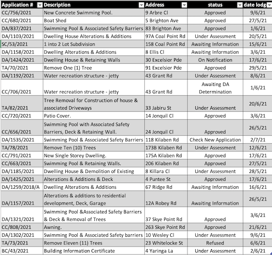
The CPPA endeavours to provide a summary of active applications in our area as outlined in the table.

Please consult LMCC’s website for a full listing: https://www.lakemac.com.au/Development/Planning-and-development-services/Application-Enquiry. 


DA = Development Application

BC = Building Information Certificate

TA = Tree Assessment 

CC = Construction Certificate, 

CDC = Complying Development Certificate, 

REF = Review Environmental Factors

SC = Subdivision Certificate.

MU = Mixed use

RFB = Residential flat Building


List of Development Applications